New Tool facilitates intuitive understanding of urban water flows
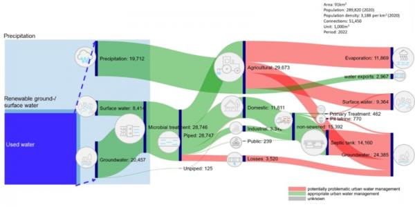
Image: Water Flow Diagram of Santa Maria Bulacan, Philippines (with permission from EAWAG)
2 Apr 2024 by The Water Diplomat
In a paper published in the journal Frontiers in Water , a research team led by the Department of Sanitation, Water and Solid Waste for Development at the Swiss Federal Institute of Aquatic Science and Technology has developed an accessible tool which helps to visualize urban water flows. In the context of rapid urbanization, population growth, and climate change, water resources are under pressure. Therefore, the presence of a visual tool which can facilitate understanding between stakeholders in dialogues on urban water security is seen as a useful instrument for effective water management.
Through the tool, the complexities of urban water management are presented in a format that is easy to understand for a broad range of stakeholders. The data is presented in a Sankey Diagram (a visual tool used to visualise flows) which has been enhanced with a colour coding which highlights the flows as ‘appropriate’ or ‘problematic’. The aim of the tool is to literally ‘visually highlight’ areas where urban water management can be improved and, in this way, to support dialogue between different stakeholders around conflicting interests and opportunities around water use. This, it is hoped, can trigger action towards more sustainable urban water management.
The tool has been field tested in four locations drawn from Europe (Bern), South America Rio Pardoa de Minas, Brazil), Southeast Asia (Santa Maria Bulacan, Philppines) and Africa (three Suburbs in Dakar, Senegal). The researchers report that the visuals created for these cities have helped to highlight different key water management issues for each city. They include pollution from agricultural production, the lack of wastewater and sanitation infrastructure, high water losses in the distribution networks, water exports leading to a lack in local supply and sewer overflows during heavy rainfalls.
For the Swiss city of Bern, most of the water flows are depicted as being in the ‘green’ zone which is associated with ‘appropriate’ water management. The city only has 5% loss of treated water in the distribution network (in some cities this can run as high as 40%), most of its wastewater is treated in an advanced wastewater treatment facility prior to its release back into the local river. Some issues of concern (‘inappropriate water management’) included the fact that some of the piped water was used in agriculture and sometimes polluted the surface and groundwater. Also, roughly 15% of wastewater in the sewer system was discharged into he environment without any form of treatment.
In the Brazilian city of Rio Pardo, the majority if water flows were labelled as ‘problematic’. The agricultural sector dominates water utilization and this water, potentially contaminated with pesticides and fertilizers, infiltrates into groundwater and surface water. Furthermore, inefficiencies in water use are apparent, as with the existing irrigation methods, more than 70% of water is lost through evapotranspiration. In comparison, domestic, industrial and public uses of water were minor, but these uses nevertheless polluted both surface water and groundwater. In the case of urban piped water, it appeared that 25% of the water is lost through the network.
In the Philippine city of Santa Maria Bulacan a large proportion of the water flows were also labelled as ‘problematic’. The city receives the majority of its water (70%) from groundwater sources, and the agricultural sector is the main consumer of water (34%) after domestic use (41%). Prominent issues in the city are the absence of a sewer network – wastewater is collected in septic tanks and pit latrines, but little of this wastewater is transported to a wastewater treatment site. In the case of agriculture, some 60% of water is lost to evapotranspiration, and a small proportion of agricultural wastewater flows into surface water bodies or percolates into the groundwater.
For Dakar’s suburbs in Senegal, more than half of the groundwater extracted was pumped to the capital city Dakar, while 47% of the water was used for agricultural purposes. The water that was used for agricultural purposes was likely polluted with fertilisers and pesticides, which is expected to have a negative effect on groundwater quality. In addition, it is estimated that 60% of the water used for agriculture is lost to evapotranspiration.
In order to compile a Water Flow Diagram, data on water flows is required, which was mostly obtained from government services, utilities, industries, universities and reports of intergovernmental organizations. The researchers report positive results from the four cases in facilitating stakeholder exchanges and stimulating debate on water management, which in the case of Senegal will probably also lead to the model being replicated and used in other urban areas.
Share this article: