Heavy Rain and Rapid Snowmelt in Upper Ural River Causes Dam Burst and Flooding
Photo: Ecohubmap
9 Apr 2024 by The Water Diplomat
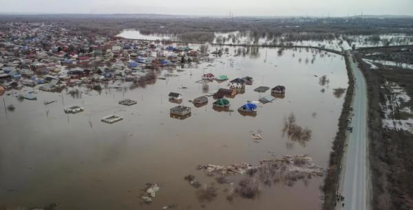
A rapid rise in the Ural River caused a dam burst leading to floods and emergency evacuations in Russia’s Orenburg region on the 6th of April. The Orsk Dam, built in 2010, was built for a water level of 5.5 metres. However, at the time of its collapse, a combination of heavy rainfall and rapid snowmelt raised water levels in the Ural River to 9,6 metres. The city of Orsk, with a population of 230,000 people, was the worst affected, with large parts of the city – including 6,000 homes, being flooded. The river also reached dangerous levels in the city of Orenburg, which has a population of 550,000 people. Russian authorities have declared a federal emergency in the Orenburg area with preparations underway to respond to flooding in three other regions. The total damage from the floods is currently estimated at around U.S. $ 227 million.
Kremlin spokesperson Dmitry Peskov stated that hydraulic stations showed that water levels in some areas had risen faster than at any time in the past 100 years. Similarly, the governor of the Orenburg region, Denis Pasler, stated that the floods were the worst to hit the region since records began. The governors of the Tyumen and Kurgan regions in Siberia were asked by the Kremlin to prepare for sharp rises in water levels.
Downstream in Kazachstan, 3,698 homes were reportedly flooded and 97,852 people were evacuated from the emergency zones. 7,173 people have been displaced in temporary shelters across the Akmola, Aktobe, Atyrau, Kostanay, North Kazakhstan, and East Kazakhstan Regions. At least 112 highways and nine bridges have been flooded. The State President has referred to the floods as a natural disaster, possibly the worst in 80 years’, and a local emergency has been declared in ten regions.
The Ural River is located in a semi-arid part of Russia and northern Kazachstan. The variability of the flow of the river both in space and in time presents challenges for the cost effective and environmentally safe water resources management. Researchers have recently pointed out the need for research into the fluctuations of the river for the purposes of long term planning.
The river rises in the Ural Mountains at 640 m above sea level and flows southwards through Russia and Kazachstan into the Caspian Sea. It is the third longest river in Europe with a length of 2, 400 km and forms the traditional boundary between Europe and Asia. For many years the river flowed freely to the Caspian Sea but the construction of twelve dams on the upstream tributaries and sections of the river in Russia have led to sharp declines in the volume of water since 2005, affecting floodplain forests in Kazachstan.
There is as yet not transboundary agreement between Russia and Kazachstan for the joint management of the Ural River, although discussions on an agreement to preserve the river's ecosystem have reportedly often been discussed in the past. In 2016, Kazakhstan and Russia signed a two-year joint action plan on the preservation of the Ural River ecosystem. Following this, in 2018, a Russian-Kazakh Commission for the Preservation of the Ural Transboundary River System was established. One of the driving forces behind the establishment of the Commission was the sharp decline in the population of Sturgeon in the Ural River due to pollution, the construction of reservoirs, and climate change.
The runoff regime of the river has been changing, as documented in scientific studies , which report that as a result of climate change, earlier commencement of flooding in the lower reaches of the river have been witnessed.
Share this article: